S-Teem Training and Coaching

A team building company in it's building and infancy stage. Be prepared when this hits the stage and market....

Saturday, October 1, 2011

The List of Legends....

These are the legends that have had the opportunity to experience something special....Keep the smiles; keep the experience...and keep the passion


Please Remember : if you hike the tracks and trails of the sunburnt country , or paddle the great waterways of this fantastic country of ours....please do not leave anything behind apart from footprints in the sand or a ripple in the water....and take nothing away except for photos and memories.


Blue Skies


Flounder

Labels:

Saturday, September 3, 2011

A Bit of History - Stoney Creek Railway Camp Hike

Hello to All Trailblazers,

It has been a while for an article in the blog.

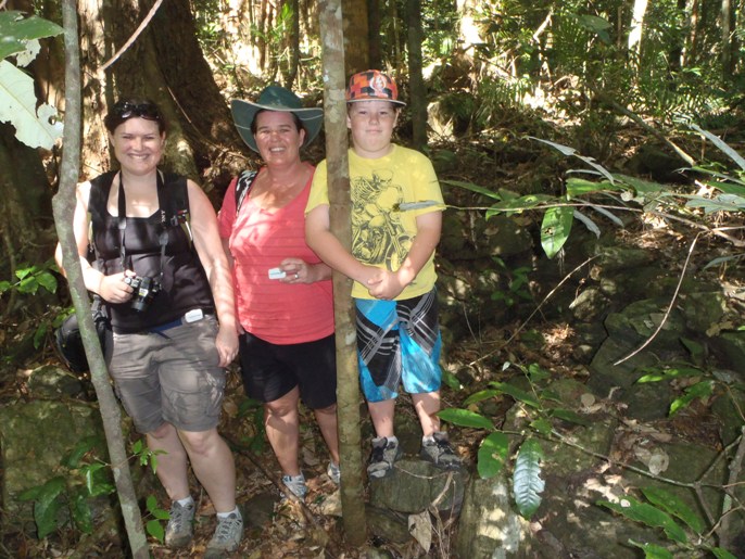
This trip was recently completed by some friends and I. Some ladies had to sign up for a Walking Challenge that the Government had organised. So I thought I can help by getting these ladies to accumulate more steps on their pedometres, and show them about hiking in rainforest plus learning a bit about local history. The crew for this day were Myself, Mel, Jo and her son Bryce.


A Lovely Autumn day greeted us and the target today was a small camp in the middle of rainforest located in the Stoney Creek gorge. The gorge itself was a part of the Barron Falls National Park.


What is significent about this relatively minor campsite, was that it was the campground of hundreds of railway workers back at the turn of the century. These railway workers gave blood, sweat, and tears (and some their lives) to build the world renowned Cairns Kuranda Railway which rose up above the Great Dividing Range to carry goods and people to the Atherton Tablelands. As you drive along the Kamerunga Road to the Douglas Track Trailhead (see previous blogs), you achieve a magnificent site of Glacier Rock and Red Bluff. You actually cross this Railway whilst hiking up the mountain range.


The trail starts at the Douglas Track Trailhead. This trail is a communication trail that supplied goods to Kuranda and the Atherton Tablelands. Most of the goods supplied were transported by donkeys and oxen.

You travel on the trail for about only 40-50 metres until you take a minor track to the west to head to the camp. The track although dubious at times, is flagged and starts with the entry point on the Douglas Track with three large rocks close together.


The track itself is about 40 minutes of clear track walking. However, since Cyclones frequent this area, you will find that there are a few downed trees to navigate around. There is also a large Bush Turkeys nest built right in the middle of the track that you need to negotiate, as well as a small creek dam, most probably built in the same era, that you have to make your way downstream for about 15 metres to find the track exit and continue your progress.


The track itself is rather undulating, but does not seriously increase in altitude. A person of low to average fitness can adequately accomplish the task.


After about 40 minutes of hiking through the rainforest, whilst dodging Wait-a-While plants, you eventually come to Stoney Creek. Please be careful crossing the creek, and the best and easiest access is usually in the Dry Season.


On the way, you will find a mutitude of photographic opportunities to a varied amount of personal liking. One of which is the amazing types of funghi that you come across. This will appeal to persons who love their flora.


Once you cross the creek and continue on the creek overflow for 5 minutes, you will come to a high creekbank. Above that lies the remnants of the old Pub and it's Oven/Bakery.
The crew is shown here with the Bakery to the right of Bryce. Please do not be mistaken that there will be any significant features. The Pub and Bakery walls only amount to a few layers of rocks placed on each other.


A significent telltale that you have reached your destination, is that the area is overshadowed by a rather large Old Man Fig Tree. This tree is substantial and the fig itself is combined with a lot of rainforest Strangler Vines.
The Fig Tree serves as a great protector of the site. If you listen carefully with the wind through the canopy, you could almost hear the joviality and laughter emmanating around the site from the old workers of the past. Beer songs and the clinking of glass echo as the ghosts of the past enjoy themselves after a hard day's toil.


The Pub itself is slightly larger in area. The Pub would be of a 3 metre by 3 metre square. 3 rock walls are evident. However, what is the most telling of all, are the remnants of old beer bottle remains from all over the site.

These beer bottles are made of old glass about a centimetre thick and would do damage to a persons foot or leg if that person was not unduly aware of the surroundings. So please be very careful traversing the site.

Once you have taken in the history of the site, you can then take the decision to retrace your steps back to the Douglas Track, or even continue onto the base of Stoney Creek Waterfall of which , on a hot day, the water would be inviting for a swim. This track leads to the famous bridge of the waterfall of which is a main promotion of the far north.

On this particular day however, the goal had been achieved and the crew made their way back to the Trailhead....right in time for lunch. Enjoyed by all, this track is the perfect introduction for hiking in the rainforest.

Remember : if ever you sample the preciousness of our wonderful far north, please take care and look after your environment. Leave only a footprint in the sand or a ripple in the water....and take nothing away except for photographs and memories.


Blue Skies


Flounder


Labels:

Sunday, July 3, 2011

Rainbows and Waterfalls....Nandroya


Hike to Mystical Nandroya Falls


On the first day of May, an intrepid crew set forth to investigate a hidden waterfall advertised in tourist mags and on National Park brochures. The promotion photos abound with beautiful waterfalls littered with pixies and elves in a golden tropical rainforest.


It was an ideal walk for some who had not hiked for a while....and even those who had not hiked at all.


Nandroya Falls was located about 20 minutes west of Innisfail in Far North Queensland. The falls themselves were located on a circuit track which were estimated at 3.5 kilometres on the eastern track and 1.7 kilometres on the Western Track.


The hiking trail itself is a fairly flat and easy negotiable track through rainforest settings with hardly any climbing involved. The Eastern track winds it's way through the rainforest, and then finds the side of the creek of which the Falls feeds into.


From the trail, the creek, of which would feed into the North Johnstone River, looks like a negotiable Grade 2 river mostly with the odd Grade 4 rapid thrown in.


Understandably, Tarzan, Timme, and Flounder were wondering if it could be paddled. However, drops of at least 10 feet waterfalls were on the cards. So if paddled, it would need to be scouted rather than a read and run.


Along the way there were a couple of waterfall crossings for the hikers, and it gave the intrepid crew a welcome break plus a great photo opportunity.

On reaching the main falls, of which the group heard before we viewed the falls, the group settled down for an early lunch.


Nandroya Falls consist of two sets of waterfalls. The higher falls which also housed the main swimming waterhole, was a 100 foot drop of majestic power. It was a sight to behold. The Lower Set of the Nandroya Falls consisted of numerous pourovers of a level set of waterfalls. Photo opportunities of both sets of falls were evidently the main drawcard of this mystical canyon.


The main waterfall emptied into a swimmable basin of freezing mountain water. However, going this far, a swim was always on the cards. The brave few could end up swimming to a few appropriate located sand bars. One of which was right next to the boil of the main waterfall.


On locating ourselves next to the main boil, we found it difficult to keep our footing on the sand with the power of the waterfall being wind and rain the strength of a category 4 cyclone.

It definately was a different experience of feeling the power of something so majestic up close.


After basking in the sun for a while , it was time to brave the lower set of falls. A motley crew of 6 ventured down through the tricky slope and out onto the unstable rocky bank of the lower falls.


This gave us the experience of a swimmable lagoon located under the waterfalls. Yes, even at this stage of the day, the water was still freezing.


Once the group had stayed for enough time to be fed, watered and relaxed, it was time to head back to the Henrietta Campground from whence we came. We completed the 1.7 kilometre track with ease enabling us to get back to the safety of our vehicles inside of 20 minutes.

All participants of the day thoroughly enjoyed themselves and found that they had been touched by the mystical qualities of the waterfall. This then trasferred into motivation to complete more hikes around the area.


Proud Supporter of Adventure Equipment Cairns.


Remember, if you plan to hike along the most wonderous trails of this great country of ours, please only leave footprints in the sand, and take away only photographs and memories our you experience.


Blue Skies


Flounder


Labels: , ,

Saturday, July 2, 2011

Confront your Fears - Split Rock - Barron Gorge

Jump into the Unknown - Abseiling Split Rock - Barron Gorge

As a part of motivating friends of mine, I had organised Pete Dumson (Roper Extraordinaire) from Top Knot Climbing to facilitate a couple of abseiling sessions on a basic rock drop called Split Rock in the Barron Gorge, Cairns.

The crew consisted mainly of the regular paddlers, and a few friends from the Department of Environment and Resource Management.


So on a balmy April Sunday morning, the first crew set foot in the gorge to challenge themselves for an introduction to abseiling. Pete led us through directions of our safety gear, and to initialise us with the practice of relaxing when being suspended on a height above the ground. Split Rock is only a 15 metre granite rock base. But the speciality of this site is that it is a flat rock all the way down and does not have features of any overhangs or craggy rock pieces to overcome.


The teams were split into two groups and everyone was keen .


Pete had people practise on a small practise rope with their descender and harness before stepping up to the main abseil.


For some, this was a challenge at abseiling for the first time. A notable reaction to first time abseiling is the trust you need to place in your equipment.


Below are some of the images of the abseil day for the team.


The experience was enjoyed by all who participated and some had come away with a new-found confidence of conquering their fears.


After each session, Pete had then led the group down to another part of the rock to show a small cave which houses small micro-bats. It also accomodates rock climbers for a crevice to scale internally.


The cave is only a small worn crack in the rock and was yet another experience for the participants to overcome. So Fear of Heights and Claustrophobia were checked off in the same day.


Well done to all who had participated for the day.


Proud Supporter of Top Knot Climbing and Adventure Equipment Cairns.


Remember, when you are hiking or boating through the natural trails and watercourses of this great country of ours, please leave only footprints in the sand or a ripple in the water, and take nothing away apart from photographs and memories.


Blue Skies


Flounder


Labels: ,

Thursday, April 14, 2011

In the Shadow of the Mountain.......

In the Shadow of the Mountain..........

Lower Behana Gorge....


Well this was the plan for a sunny Autumn day. Unfortunately, the plan did not come to fruition as when the crew got to the measurement guide, it seemed to be too large for our skills. The Measurment Guide as per our adviser Deb, is that the water running over the causeway below the Behana Gorge Carpark, should be below ankle deep. Unfortunately this was not the case.


Decision making was made and the crew under impromptu pushing from Craig (another gun), The mighty Russell River was chosen as the target. Yep, the crew were about to step up....


The Mighty Russell River....


Rocks, Tree Branches, cold water, ducking, diving, swerving, swinging the kayak to miss obstacles, leeches.....and that was just the hike in !!!!


Yep, the hike in for newby's is a very tough 3k's with a boat on your shoulder. In the team were Craig, Flounder, Adro, Sandy, Laggy, Gonz, and the indefatigable Tarzan. Incidentally, Tarzan had Timme's boat....which was lightweight....but he was uncertain about a smaller boat in a bigger rapid for the first time.


There were two major creek crossings for the hike in, and the crew made the most of the second crossing. Very cold refreshing water livens up the soul.


Not long after we arrived at the drop in. We had a small break (which I sooner learnt that it wasn't big enough).


We received a surprise when Deb and Jeremy turned up. That now made the numbers as 1 gun per 2 novices which were great odds.


Our introduction was the Leichardt Rapid, a solid Grade 3 of which looked straight out of the movie Deliverence. Flounder did a turn of significance due to the fact that he did not panic in the midst of churning water. Tarzan had carried a small gecko transported from Timme's place. Tarzan went for a swim himself and was surprised that the gecko had a bath in a washing machine. The gecko was let go in new surroundings of which he would be very anxious let loose in the jungle in the shadow of the Mountain.


After boats and gear of swimmers introduced to frothing water was collected, we were off for the next small grade 2 followed by a small grade 3. The interesting thing about the Grade 3 which shows Adro's yellow helmet, was that there were two large holes and as paddlers , the group had to cicane through the turmoil one by one.... All passed with flying colours.


Once that was completed, it was now time for yet another step up. We found that we were on a river with big water.....and bigger than Craig had initially thought. The next rapid was "Three Ways". This can be a very dangerous rapid and has been fatal in recent years. The dangerous part being the imposing rock in the midst of the rapid. It is undercut....and to the left of the rock, there are a few sieves which are fatally dangerous to paddlers.


Jeremy, Deb, Craig, Adro, Sandy and Gus were the ones to try this rapid with successful outcomes.


The other crew were just happy to portage around. It was at this point I had realised I was dead tired from carting my boat everywhere in the Shadow of the Mountain.


The Waterfall Rapid. At this level, it was considered dangerous. The crew had spent at least half an hour discussing options. I had landed on a separate rock island to the main crew, and looking around, I realised in horror that we had to run this rapid. there was no portage around.


What made the Waterfall dangerous was that there was a massive hole that would hold you for days if you were caught in there. So we didn't want to go there !!!! Option 1 was the Chicken Shute which seemed viable to the crew, and Jeremy successfully ran it, then Deb also . However, the crew chose option 2... the Chicken Drop . The Chicken Drop, even though is not seen here clearly was the best option for us novice paddlers.


I was worried in regards to reading this rapid (the Chicken Shute) as I was thinking about the recirculation of River right of the big catch rock at the bottom. That is if you were swimming this. However, I was to be proved wrong shortly.


The Chicken Drop was about 2 metres of a hard rock slide of which Tarzan and I had done successfully. Unfortunately, Laggy had made the decision to run it then changed his mind and went down the Shute....indecision kills... From this point I am unsure of what the rest of the crew had done, as I was paddling hard to river left to get to the portage area for the next rapid to aid the guys with Laggys Boat. The next rapid was the Rollercoaster of which the guns ran successfully . Everyone else portaged.


The Rollercoaster....a Grade 4 living hell that you must hit right at the sweet spot. Apparently it is a quick ride down....if you hit it at top speed. River right is the direction and all you have to do is keep your balance....apparently !


Next was a smaller decent Grade 2 of which was to prove my downfall. My downfall was brought about by broadsiding some large standing waves at the bottom of this. I then got separated from my boat of which Craig and Adro chased. The boys had chased my boat until it got hung up on a tree branch on River right just at the gates of the next Grade 2. From there, my boat, with a little bit of adjustment from Adro, then promptly travelled the rest of the river without me. From here my river tales differ from the crew. My experience of the last three rapids were of climbing over Cyclone Yasi trees, dodging Wait-A-While, and uttering very loud technical terms.
I did however get to have a decent view of the bend in the river for which I could see the crew's antics.

The Standing Wave Rapid is a rapid which has a couple of breaking waves in which could unseat the unwary paddler. At this level, it would be one hell of a pushing wave. From my perch high atop the ridge, I had seen Laggy and Adro both go for a swim....whilst the young gun Gonz, successfully negotiated his way through.


Gonz then paddled his way through some splashes onto the last main rapid of the day.


This is where Gonz had his fall from Glory. His brace was not quite correct and thus he went swimming all the way to the get out at Golden Hole.


Jeremy ended up passing his paddle to soapslick hands Adro. As Adro had then lost his third paddle of the day from his grasp. Adro must have been tired as he also went swimming at the last rapid....I would say he would have been tired from the full day out as I can attest to.


At long last we reached the placid water of Golden Hole. However, we did not stay in those depths for long....due to prehistoric lizard sightings made a while back. But it seemed to be a fruitful day and in the aftermath of the journey, everyone from the work team did own up to be very weary over the next few days.


Thanks for the day go to Craig, Deb, and Jeremy for not only their humorous remarks on our paddling styles, but their ever consistent lookout for our safety.


Remember : if you are paddling in the fabulous waterways or our great country, please do not leave any more than a ripple in the water and a footprint in the sand, and take nothing away but photographs and memories of your wonderful adventure


Blue Skies everyone


Flounder


Proud Supporter of Adventure Equipment Cairns, and Top Knot Climbing


Labels: